Log Cabin Tree

By Will Murray

A tense standoff ensued between a saw crew and neighbors in Broadview Thursday morning May 8th over what neighbors are calling the Log Cabin Tree. The Ellsworth family lived in a log cabin on the property since 1934 and the property was recently sold. The Log Cabin Tree is a Western Red Cedar tree with a 68” trunk diameter and reportedly over a 100 years old. The group of neighbors hired an arborist who looked at the property lines and determined the tree may possibly be co-owned with the neighbors to the north. The new property owners have pressed paused on the cutting of the Log Cabin Tree as ownership issues can be determined.

Thursday May 8th neighbors gathered to enjoy coffee and donuts near the Log Cabin Tree a Western Red Cedar with multiple trunks and a 68 “diameter.

The Ellsworth Family’s log cabin was built in 1934 from trees harvested in Broadview. The cabin was recently demolished to make room for a multi-family development.


Carkeek Park Intermittent Closures for Geotechnical Work


Seattle Parks and Recreation asks for park visitors’ cooperation

Seattle Parks and Recreation (SPR) will implement intermittent closures at Carkeek Park during the week of May 5–12, 2025, to support geotechnical work for the Carkeek Pedestrian Bridge Replacement Project.

These closures are necessary for the safe completion of two geotechnical borings on Carkeek Park beach, which will assess soil conditions critical to the design and construction of the new pedestrian bridge. Crews will conduct major work every other day during the week, with staging and drilling activity occurring both onshore and at the beach.

The exact closure dates are Tuesday, May 6, from noon to 5 p.m.; Thursday, May 8, from 8 a.m. to 1 p.m.; and Saturday, May 10, from 7 to 11 a.m. Please note that all work is weather dependent and subject to change based on site conditions. The full work schedule is as follows:

  • Monday, May 5 (Park Open):
    The contractor will begin staging equipment at the Model Airplane Field in the park or on the beach. Some parking spots near the pedestrian bridge will be closed, visitors must avoid areas marked by caution tape to ensure safety.
  • Tuesday, May 6 (12 – 5 p.m., Park Closed):
    Parking near the pedestrian bridge and all roadways and pathways leading to the Model Airplane Field will be closed. The pedestrian bridge and beach will be fully closed. A helicopter lift will transport drilling equipment to the beach. Noise and visible construction activity are expected. The drill rig will remain on the beach overnight, surrounded by cones and caution tape. All areas will reopen in the evening.
  • Wednesday, May 7 (Park Open):
    Drilling will occur on the beach, with continued loud noises and crew presence. The park will remain open.
  • Thursday, May 8 (8 a.m. – 1 p.m., Park Closed):
    Parking near the pedestrian bridge and all roadways and pathways leading to the Model Airplane Field will be closed. The pedestrian bridge and beach will be fully closed. Helicopter lift operations will continue, including repositioning the drilling equipment to a second location on the beach. The drill rig will remain on the beach overnight, surrounded by cones and caution tape. All areas will reopen in the afternoon.
  • Friday, May 9 (Park Open):
    The drilling will continue on the beach with noise and visible activity. The park will remain open.
  • Saturday, May 10 (7 – 11 a.m. Park Closed):
    Parking near the pedestrian bridge and all roadways and pathways leading to the Model Airplane Field will be closed. The pedestrian bridge and beach will be fully closed. The helicopter will remove drilling equipment from the beach and return it to the Model Airplane Field staging area.

Please refer to the map below for detailed closure areas and staging locations.

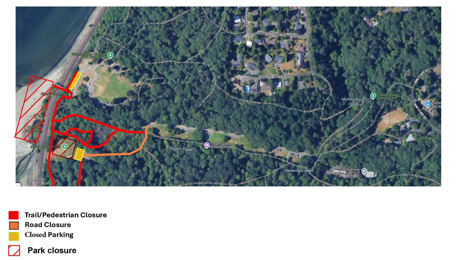
SPR requests all visitors to follow Park Ranger instructions, observe closure signage, and respect fencing and caution tape to help ensure everyone’s safety. These temporary closures are a necessary step in improving park infrastructure and enhancing long-term public access to the beach at Carkeek Park. We appreciate your patience and cooperation.

For more information, please visit https://www.seattle.gov/parks/about-us/projects/carkeek-park-pedestrian-bridge-replacement or contact kellina.stamm@seattle.gov.

Celebrate Neighbor Day on May 3, 2025

Celebrate Neighbor Day by amplifying kindness and building community.

Seattle City Light’s Upcoming Time of Use (TOU) Rates

Seattle City Light will introduce a Time of Use (TOU) rate in 2025, giving customers a new way to manage their energy use and lower their bills.

To help you understand how this will work, we asked the TOU team to explain the basics of TOU rates and how they can benefit your household and the broader community.  

Q1: What are Time of Use (TOU) rates? How do they work?  

Time of Use rates are electricity prices that change depending on the time of day you use energy. They’re designed to reflect fluctuations in demand. The cost is lower during off-peak hours, when demand is lower, and higher during peak hours, when demand is at its highest.  

For example, If you run your dishwasher at 12 a.m., during an off-peak period, it will cost less than running it at 6 p.m., during peak hours. This new rate system gives you more flexibility to save money by making small adjustments to when you use electricity.  

It’s about more than saving money, though. Using energy during off-peak hours can also help balance demand on the power grid, which helps contribute to the energy system.  

Q2: Why is Seattle City Light introducing a TOU rate?  

We’re offering a TOU rate for a couple of key reasons. First, it’s about providing options. TOU pricing gives customers new ways to control their energy bills.  

Second, it’s about making the grid more efficient. When we shift some energy use to off-peak times, it reduces strain during high-demand periods. That makes the system more reliable and helps us avoid investing in costly new infrastructure.  

Finally, it aligns with our energy goals. When demand is spread more evenly, it’s easier to rely on clean, renewable resources, such as solar and wind, which can have varying availability throughout the day. This pricing system is part of a long-term plan to create a more sustainable energy future for our communities.  

Q3: What are the peak and off-peak hours?  

We will be using a three-tiered peak system for our Time of Use rate: peak, mid-peak, and off-peak. The price you pay for electricity will depend on when you use it. Here are our TOU hours:

  • Peak hours are when electricity is most expensive. This will be from 5 p.m. to 9 p.m., Monday through Saturday, except on city-observed holidays. This is when demand is highest, as people are typically settling in after work and school, running appliances, charging cars and devices.
  • Mid-peak hours will be from 6 a.m. to 5 p.m. and from 9 p.m. to midnight, Monday through Saturday. On Sundays and city-observed holidays, mid-peak pricing applies all day from 6 a.m. to midnight (with no peak hours).
  • Off-peak hours are when electricity is lowest. This will be from midnight to 6 a.m. every day.

In general, peak electricity rates are twice as high as off-peak rates, with mid-peak pricing being 1.75 times as high as off-peak. If you can shift some of your energy use, like running appliances, to mid- and off-peak times, you can save money.

Q4: How are TOU rates calculated? How do they compare to flat rates?  

City Light currently uses flat rates, which charge the same price for electricity regardless of when you use it. While simple, flat rates don’t account for how electricity production and delivery costs rise and fall throughout the day.  

TOU rates, on the other hand, have time-based pricing. They’re calculated based on: 

  • The cost of generating and distributing electricity at different times of day. 
  • Demand, which spikes during peak hours 

When demand is high, it costs more to produce and deliver electricity, so peak hour rates will reflect that. During low-demand periods, production costs drop, and so do rates.

For many customers, switching to TOU rates can mean savings with just a few easy adjustments, like running appliances or charging electric vehicles during off-peak hours.  

A brighter energy future  

TOU rates can give you more control over your electricity costs while supporting a more reliable and cleaner energy system. This is an exciting step for Seattle as we move toward a greener future.  

Stay tuned for more updates as the rollout approaches in 2025. For now, start exploring how you can adjust your energy use by creating an online account at the Utility Services Website.

If you’d like to stay informed about TOU, sign up here to receive email updates on Time of Use rates. Get ready for a brighter, more sustainable tomorrow!  

SDOT Work on N 130th Starting Soon

SDOT announced they plan to begin work to reconfigure N 130th St from Stone Avenue North to 1st Avenue NE, as soon as late April. Here’s their announcement:

“We’re getting ready to redesign N 130th St from Stone Ave N to 1st Ave NE for safer travel, better connections to Sound Transit’s future Pinehurst Light Rail Station, and to support new all-day bus service for King County Metro’s Route 77 arriving next year.

Starting as soon as late April, we will redesign the street from its current 4 lanes (2 lanes in each direction) to 3 lanes with 1 vehicle lane in each direction, a center turn lane, and new protected bike lanes that people on scooters can use too. As we get closer to starting work, we’ll share the schedule and expected construction activities.”

SDOT also shared the project will include:

  • Reducing the speed limit on N 130th St from 30 mph to 25 mph to improve safety for all users
  • Redesigning the street from 4 lanes to 3 lanes with 1 vehicle lane in each direction and a center turn lane to improve safety
  • Installing protected bike lanes on both sides of the street to improve safety and connections for people on bikes and scooters. The bike lanes also provide an additional buffer between the street and the sidewalk to create a more comfortable walking and rolling space.
  • Adding protected left turns at Meridian Ave N, Ashworth Ave N, and Stone Ave N to improve turning operations and safety through these intersections
  • Adding ‘No Turn On Red’ restrictions at 1st Ave NE, Meridian Ave N, Ashworth Ave N, and Stone Ave N to improve pedestrian, bicycle and overall operational safety

SDOT adds:N 130th St between Aurora Ave N and I-5 is a high collision area with a history of serious injuries for people walking and biking. The new street design reduces conflicts between people driving and people walking, biking, and scooting, and makes it easier for people driving to safely make left turns using the center turn lane.”

Here’s the full street design, including intersection designs.

Here’s a map of Route 77, which will open in 2026 along with service to the Pinehurst Station at 130th. It will connect Bitter Lake, Haller Lake, Lake City and Meadowbrook to the new station.

Bitter Lake Community Center Pancake Breakfast


Join us at Bitter Lake Community Center on Sunday, February 23, 2025, for our annual Pancake Breakfast Fundraiser!

Enjoy a delicious breakfast while supporting our programs and scholarship fund!  Featuring free disaster preparedness skills fair.

All you can eat pancakes! Other breakfast food and drinks will be provided. Gluten free and vegan options will be available.

$6 per person.

Register here.

Donate here.

Questions? 206-684-7524

Open house for the N 130th Bitter Lake to Haller Lake Project

SDOT is in the early design phase for the N 130th Bitter Lake to Haller Lake Project. They are hosting a drop-in session where you can learn more and share feedback:

  • WHEN: Tuesday, February 4 from 4 – 7 PM
  • WHERE: Bitter Lake Community Center (13035 Linden Ave N)

You can also take a survey.

According to SDOT the improvements are designed to create connections to the future Pinehurst light rail station at 130th, scheduled to open in 2026, and improve safety and bus reliability.

Potential road configurations are shown on the project webpage. Project elements include road paving to support increased bus service, a new street design with a center turn lane and one vehicle lane in each direction in most areas, new crossings, upgraded and relocated bus stops, protected bike lanes, improved sidewalks with curbs and accessible curb ramps, planting strips with street trees, and drainage and stormwater improvements.

You can also give your feedback or ask questions about the project by email at N130st_BitterLake_HallerLake_Project@seattle.gov.


NE 130th & 125th St project

The NE 130th & 125th St project has reached final design, supporting connections to future light rail. Sound Transit (SDOT) is opening the NE 130th St light rail station in 2026 and Seattle Department of Transportation is making sure that people can get there safely and comfortably.

To support the 90% of light rail riders expected to get to the new station by walking, biking, rolling, or taking transit, SDOT designed a set of improvements that include improved crossings, a new street design, traffic calming, curb-protected bike lanes, transit upgrades, and more.

Learn what is involved and how it may affect you.

Projects planned in North Seattle to improve access to the future NE 130th St light rail station which opens in 2026.