12th Ave NW Basin Drainage Improvement Project Update

Below is the most recent project update from Seattle Public Utilities.

Project Update, August 2022

Last month, we reached out with an update on the 12th Ave NW Basin Drainage Improvement project to share that the construction of the pipe and conveyance elements was slated to begin in late July or early August 2022. Since then, construction has begun, and the contractor has completed the following tasks:

  • Replaced sanitary sewer maintenance holes
  • Pruned trees to make room for construction equipment
  • Staged materials along the street to expedite installation
  • Checked for underground utility conflicts on NW 125th St

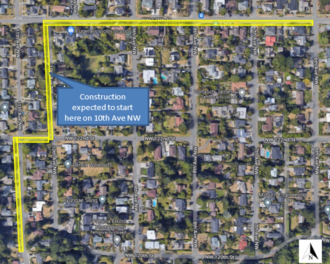
The contractor started the underground work at the intersection of 10th Ave NW and NW 125th St, and their plan is to continue working eastward along NW 125th St until reaching 6th Ave NW. Following that, they will relocate to 11th Ave NW, moving northward along 11th Ave NW between NW 120th St and NW 122nd St. They will then work along NW 122nd St between 11th and 10th Ave NW. The last leg of construction will then take place along 10th Ave NW, between NW 122nd St and NW 125th St. Please see the highlighted area on the map below for the work areas.

Due to an unforeseen conflict with a water main and the proposed storm pipe, the current work along NW 125th took a temporary pause. The contractor’s work is expected to resume today, August 31. You might have seen the contractor doing minor work in other parts of the project area during this pause. SPU crews plan to resolve the water main conflict on September 1, and properties that will experience water service interruptions have been notified.

The contractor will soon be staging two large water treatment tanks within the project area’s right-of-way, most likely along NW 122nd St. These tanks will minimize project-related sediment pollution by removing sediment from water used during construction before the water is discharged into the system. We will reach out directly to homes that are near where the tanks will be staged.

The underground work is expected to be complete in 2022. Final paving is weather dependent and planned for early 2023. Work will take place Monday through Friday, from 7am to 4pm.

Map showing underground pipe and conveyance work area

Anticipated Impacts

During construction you can expect:

  • Construction-related noise, dust, vibrations
  • Restricted street parking near work zones
  • Partial lane closures
  • Equipment being stored in the right of way
  • Temporary access restrictions and limited access to some driveways during daytime working hours

Pedestrian access and access for essential services (such as emergency vehicles, mail delivery and garbage pickup) will always be maintained.

Any temporary access limitations to driveways will be communicated in advance by the construction management team.

Construction Safety is Everyone’s Job, check out some top safety tips at: www.seattle.gov/utilities/constructionsafety

Natural Drainage System Project Update

The project team is close to reaching 90% design completion on the Natural Drainage System (NDS) project elements. The project team will be reaching out to residents in the immediate project area in the next month, and will be providing opportunities for the broader community to learn more about the NDS project in the upcoming months.

Looking ahead

We will continue sending monthly email updates with the latest information about the anticipated project schedule, construction progress, and impacts. Please encourage your neighbors to sign up by visiting our project website.

If you live near the Natural Drainage System portion of the project, please keep an eye out for a mailer or email update with opportunities to connect with the project team and learn more about the upcoming NDS construction.

Thank you!

We want to thank you for your patience during construction. We know construction can be disruptive, and we appreciate your understanding as we work to complete this necessary upgrade to your neighborhood’s drainage system. We always strive to make our projects as easy on the community as possible.

As always, if you have a question about the project, please feel free to contact the project manager directly by emailing Sierra.Gawlowski@seattle.gov

Best,

Broadview Project Team

Visit the project website

Candidates Forum at the Haller Lake Community Club on September 8th

The Broadview-Bitterlake Community Council is co-sponsoring a Candidates forum with the Haller Lake Commynity Club again. It will be live at the Haller Lake Community Club or on zoom. The list of candidates is below. Please submit questions ahead of time. You can use this email for questions. Make sure to identify which candidate the question is for.

Meeting

Thursday, Sept. 8, 2022 at 7:00 PM – 8:30 PM

Topic: Candidates’ Night

Come hear from candidates running in Haller Lake and Bitter Lake. The following candidates have confirmed attendance:                

  • Cliff Moon US Congressional District 7
  • Julie Anderson Secretary of State
  • Patricia Weber State Senate District 32
  • Cindy Ryu (remotely) State Rep. District 32 Position 1
  • Lauren Davis State Rep. District 32 Position 2
  • Mathew Gross State Senate District 46
  • Javier Valdez (through campaign manager) State Senate District 46
  • Gerry Pollet State Rep. District 46 Position 1
  • Darya Farivar State Rep. District 46 Position 2
  • Lelach Rave State Rep. District 46 Position 2

There will be cookies for in-person attendees outside from 6:45 to 6:55. Meeting starts at 7:00 sharp inside, masks highly recommended.

Open to all.

Where: Haller Lake Community Club and Zoom: https://us02web.zoom.us/j/84789477952?pwd=MHJrUUZyM2U3NGJRRFJDRE85bmtCdz09

Broadview-Bitter Lake Community Council

Our NEW Website:             www.broadviewbitterlake.org

Our NEW Email:                 BroadviewBitterLakeCC@gmail.com

Like US on FACEBOOK:    https://www.facebook.com/broadviewbitterlake/


Transit, Cameras and Maps to Help Your Travel

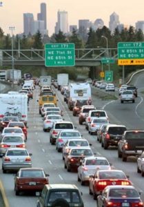
When you ride public transit Metro Transit or Sound Transit do the driving for you.  Use transit for your travel whenever possible. But if you for some reason need to drive there are ways to be time and fuel (pollution) efficient.

Many drivers use some kind of traffic information to help plan and manage their trips. Here are a couple online sites that give real time travel information.

The Washington State Department of Transportation has a map showing travel alerts. This time of year. road construction is often a reason for traffic delays. The Travel Center Map site covers the whole of the state.

The Seattle Department of Transportation has a travelers map showing web cameras and other links like traffic incidents and travel times.

Remember that how you travel has an impact on you and everyone else.


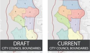
Seattle Redistricting Commission seeks public comment on draft map of new City Council Districts

The Seattle Redistricting Commission is currently in the process of redrawing the boundaries of Seattle’s seven City Council Districts. Over the past five months, the Commission has hosted or participated in more than 50 community information sessions, a community survey, and seven public forums to gather feedback from the public about the redistricting process and its potential impact on neighborhoods. This process has resulted in the Commission adopting a draft map of new City Council District boundaries. Members of the public are invited to submit comments on the draft map and its proposed district boundaries.

“For the first time in Seattle’s history, we are engaged in redrawing the lines of the seven City Council districts,” said Greg Nickels, Seattle Redistricting Commission Chair. “My fellow commissioners and I are taking great care to listen to the public as we are doing our work. Adopting a draft map is a big step forward in that process.”

The Commission’s draft map was generated at an open public meeting of the Seattle Redistricting Commission on August 2 and was informed by the public comments submitted over the last five months. The map follows City Charter and state-mandated criteria using geographic information system (GIS) expertise and 2020 Census data to draw new boundaries and establish districts that are compact, contiguous, and approximately equal in population. The map also accounts for additional factors such as, to the extent practical, following existing district boundaries, recognizing waterways and geographic boundaries, and to the extent possible, preserving Seattle’s existing communities and neighborhoods.

Public Comment

A discussion of the final draft map will now begin and both public comment and participation are requested by the Seattle Redistricting Commission. Members of the public can review the final draft map and offer feedback at https://www.seattle.gov/redistricting/how-to-participate.

The designated public comment period is open from August 3, 2022 until the date the Commission files the final district plan, which is currently scheduled to be November 8, 2022, and shall be no later than November 15, 2022.

If you would like to obtain a physical copy of the draft map, please contact Logan Drummond at Logan.Drummond@seattle.gov. You can also find a copy at the customer service desk in Seattle City Hall, located at 600 Fourth Avenue.

Public comment can be made:

  • In-person at one of three Public Forums
    • Public Forum #1: Tuesday, August 9th, 12:00 p.m. – 1:30 p.m.
      Physical Location: Seattle City Hall, 600 Fourth Avenue, Boards & Commissions Room L280
      Virtual Link: https://us06web.zoom.us/j/84697105761
    • Public Forum #2: September – date and time TBD
    • Public Forum #3: October – date and time TBD
  • In-person at any regularly scheduled Seattle Redistricting Commission meeting. Check the Seattle Redistricting Commission website for dates and times.
  • In writing using the Seattle Redistricting Commission’s public comment submission form.

For more information, or to request interpretation services for any of the public forums, please contact Elsa Batres-Boni at Elsa.Batres-Boni@seattle.gov or (206) 256-6198.

For more information about the Seattle Redistricting Commission, visit http://www.seattle.gov/redistricting.

THE AURORA AVE PROJECT SURVEY IS NOW OPEN

The Seattle Department of Transportation is seeking community input to understand the challenges that people face traveling along the corridor. In addition to pedestrian and bike safety, the survey asks about transit ridership along Aurora and how you use the E-Line.

Take the survey now

This is your first official chance to share what is unsafe about Aurora. The survey unfairly asks you to rank* several much-needed safety improvements. We need sidewalks AND signalized crossings!
A great deal of nuance is avoided in this survey. Nevertheless, it’s important to take a minute and remind SDOT that we need an Aurora Avenue that puts people first.

*Be careful when ordering these rankings – the higher numbers are sometimes “most needed/important” and sometimes the lower numbers are.

The survey also doesn’t leave much room to share your thoughts on the many other problems that are directly connected to Aurora: crime, land use, climate impacts, personal safety, etc.

The Aurora Reimagined Coalition is committed to advancing these issues and addressing the corridor holistically. Send us a message if you’d like to get involved.

For more information about suggested responses see at this link.

WHY DO WE NEED MORE SIGNALIZED, STREET-LEVEL CROSSWALKS?

  1. They allow everyone – people walking, biking, using a wheelchair, or pushing a stroller – a safe and easy way to cross the highway
  2. Additional signals at key locations will change people’s perception of Aurora as a through-highway into a more dense urban main street, which will significantly change traffic behavior (notice the difference in speed and driver behavior between the Fremont section and the Licton Springs section of Aurora)
  3. An additional crossing near a busy or dangerous intersection can give people walking, biking, and rolling a safer option, which will reduce the load on that major intersection (an example of this is N 92nd Street)
  4. Delays to transit can be minimized using the electronic system that gives buses a head-start at stoplights
  5. Coordinating bus stops with new crossings can improve transit riders’ experience and encourage ridership


Hot weather safety

Hot weather is expected in the Seattle area next week. Higher temperatures can lead to heat-related illnesses such as heat exhaustion and heat stroke. Fortunately, there are ways to prevent becoming ill from too much heat.

Too much heat and sun can overwhelm anyone but those most at risk from heat exhaustion and heat stroke include older adults, young children, and people who work or exercise outdoors.

Signs of heat exhaustion include:

  • Sweating
  • Pale, ashen or moist skin
  • Muscle cramps (especially for those working or exercising outdoors in high temperatures)
  • Fatigue, weakness or exhaustion
  • Headache, dizziness or fainting
  • Nausea or vomiting
  • Rapid heart rate

Heat exhaustion can lead to heatstroke if proper steps are not taken to reduce overheating.

Heatstroke is more serious and occurs when the body reaches a temperature of 104 degrees or higher. It is usually a result of prolonged exposure to high temperatures or physical exertion in high temperatures.

In addition to the above heat exhaustion symptoms, heatstroke symptoms can include:

  • Confusion
  • Altered speech
  • Nausea or vomiting
  • Rapid breathing and a racing heartbeat, among other symptoms.

Call 9-1-1 immediately if any of these symptoms occur.

Stay Safe in the Heat

  • NEVER leave children, pets, or people with limited mobility in a parked car, not even for a minute! Cars get dangerously hot in seconds!
  • Drinking water and other fluids often is important. Don’t wait until you’re thirsty!
  • Check on family and neighbors who may be more vulnerable to heat.
  • Children can also have heat exhaustion because they are so active and forget to drink water.
  • Keep children out of the direct sun during the hottest part of the day.
  • People who work outside should take frequent breaks to cool off.

How to Cool Down 

  • Play in fountains and sprinklers, go to the swimming pool, and stay in the shade.
  • Try to go somewhere with air conditioning on a hot day or visit one of the cooling centers in King County
  • Continue to hydrate

For more information:

Centers for Disease Control and Prevention

National Safety Council

Seattle-King County Public Health heat safety tips

Download the “Stay Safe in the Heat” comic strip in multiple languages: EnglishAmharicArabicChineseFrenchKoreanRussianSomaliSpanishTagalogUkrainianVietnamese

12th Ave NW Basin Drainage Improvement – July project update

From Seattle Public Utilities 

Last month, we reached out with an update on the 12th Ave NW Basin Drainage Improvement project to share that the design for the underground detention pipe and conveyance project elements had been completed and a contractor had been selected. We are now excited to share that construction of the pipe and conveyance elements will begin in late July or early August 2022, and potentially as early as July 25, 2022.

We expect construction to last approximately 6 months, with work taking place Monday through Friday, from 8 am to 5pm. The underground work is expected to be complete in 2022, but this is subject to change due to weather and other factors. Final paving is weather dependent and planned for early 2023.

This work will be done in the public right-of-way along 11th Ave NW between NW 120th and NW 122nd St, 10th Ave NW between NW 122nd and NW 125th St, and along NW 125th St from 10th to 6th Ave NW. See highlighted area on the map below. The contractor expects to start installing underground pipe on 10th Ave NW and proceed north and east along NW 125th Street. Afterward, they will start at the south end of 11th Ave NW and proceed north to their starting point. Tree trimming in the right-of way will take place before underground construction can start.

There is no update on the natural drainage systems element of the project, as it is still being designed and construction has been rescheduled.

Map showing underground pipe and conveyance work area

Anticipated Impacts

During construction you can expect:

  • Construction-related noise, dust, vibrations
  • Restricted street parking near work zones
  • Partial lane closures
  • Equipment being stored in the right of way
  • Temporary access restrictions and limited access to some driveways during daytime working hours

Pedestrian access and access for essential services (such as emergency vehicles, mail delivery and garbage pickup) will always be maintained.

Any temporary access limitations to driveways will be communicated in advance by the construction management team.

Construction Safety is Everyone’s Job, check out some top safety tips at: www.seattle.gov/utilities/constructionsafety

Contact Us

Direct replies to GovDelivery email messages will not be received by the project team. As always, if you have a question about the project, please feel free to contact the project manager directly by emailing Sierra.Gawlowski@seattle.gov

Where should Seattle build homes for newcomers?

From KUOW, Joshsua McNichols

The City of Seattle is planning for more growth and it wants your input.

Should the city keep funneling newcomers into dense neighborhoods known as “urban villages” — or should it spread density out across more parts of the city, including neighborhoods dominated by older homes?

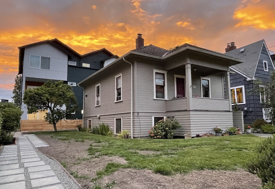
caption: A single-family home in Seattle's Greenwood neighborhood with infill housing in the backyard.

Seattle doesn’t get to choose whether it grows or not. Companies keep adding jobs, which means more people will come.

But the city can plan for where it puts those new arrivals. In fact, it has to, according to Washington state’s Growth Management Act.

Seattle has somewhere around three-quarters of a million people right now. Despite a slowdown in growth during the pandemic, it’s expecting to add another quarter million — about the population of Spokane — by the year 2044. That would bring the population of Seattle to one million.

Right now, most of the new homes being built in Seattle are in “urban villages.” They feature dense clusters of apartment buildings clustered around good transit and townhomes in the splash zones on their peripheries.

The city’s considering five alternatives, as it works on updating its comprehensive plan.

See the full article here.